Karum Kanesh
Kültepe, Turkey · Established c. 1950 BCE
This site requires authorization to access.
To request access, contact
william.goetzmann@yale.edu
The archaeological site of Kültepe—ancient Kanesh—comprises two distinct zones: a circular mound (höyük) roughly 550 by 500 meters in diameter and rising 21 meters above the surrounding plain, and a lower city (the kārum) extending in a crescent to the south and southeast. The mound housed the citadel of the Anatolian kings, with palaces and temples, while the kārum below served as the commercial quarter where Assyrian and local merchants lived and conducted business. As Mogens Trolle Larsen detailed in *Ancient Kanesh: A Merchant Colony in Bronze Age Anatolia* (Cambridge University Press, 2015), the kārum contained densely packed mudbrick houses organized along narrow streets, with individual dwellings typically consisting of several rooms arranged around a central living area. Merchants stored cuneiform tablets in sealed clay containers beneath the floors or within designated archive rooms of their homes. Approximately one hundred houses have been excavated in considerable detail, revealing the settlement patterns of a mixed community of Assyrian traders and native Anatolians. The site first attracted scholarly attention in 1881 when local villagers unearthed cuneiform tablets. In 1925, the Czech Assyriologist Bedřich Hrozný conducted the first systematic excavation, locating the source of the tablets in the lower city. The modern excavation program was initiated in 1948 under the direction of Tahsin Özgüç of the Turkish Historical Society, who led continuous fieldwork for fifty-seven years until his death in 2005. Özgüç’s campaigns revealed eighteen superimposed occupation levels in the mound, with the kārum’s most significant strata being Level II (c. 1950–1835 BCE) and Level Ib (c. 1798–1740 BCE). Since 2006, Fikri Kulakoğlu of Ankara University has directed the excavations, uncovering monumental Early Bronze Age structures with walls up to four meters thick beneath the Assyrian-period levels, as well as previously unknown domestic architecture on the citadel mound. The site was placed on Turkey’s tentative list for UNESCO World Heritage status in 2014. Today the exposed mudbrick foundations of the kārum lie open to the elements on the central Anatolian plateau near the city of Kayseri.
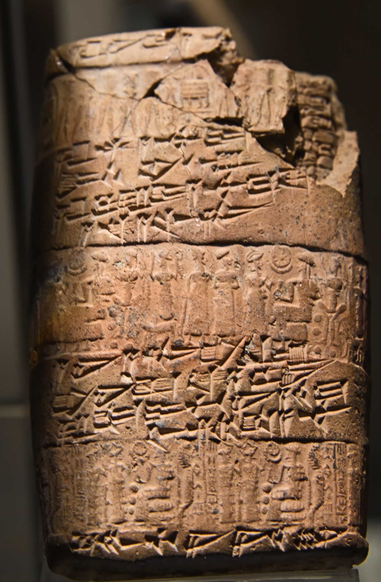
The kārum of Kanesh has yielded one of the richest assemblages of glyptic art from the ancient Near East. As Nimet Özgüç documented in *The Anatolian Group of Cylinder Seal Impressions from Kültepe* (Türk Tarih Kurumu, 1965), thousands of cylinder seal impressions were recovered from clay tablet envelopes (bullae) used to authenticate commercial documents. These seals display a remarkable stylistic hybridity: some were carved in a distinctly Mesopotamian idiom depicting contest scenes, divine processions, and mythological narratives, while others belong to an indigenous Anatolian tradition characterized by large-eyed figures, distinctive deities, and local religious iconography. Agnete Wisti Lassen, in her study “The Old Assyrian Glyptic Style” in *Current Research at Kültepe-Kanesh* (Lockwood Press, 2014), distinguished a specific “Old Assyrian” glyptic style produced for the merchant community, featuring presentation scenes before seated deities and interceding goddesses. The bullae themselves are significant artifacts: merchants enclosed tablets within clay envelopes impressed with the cylinder seals of the parties involved and of witnesses, creating a tamper-evident system of commercial authentication that represents one of the earliest known forms of notarized documentation. More than a thousand bullae with seal impressions from the Early Bronze Age levels, predating the Assyrian colony, were discovered during Kulakoğlu’s recent excavations, as reported in *Antiquity* (vol. 89, 2015), demonstrating that Kültepe was integrated into interregional exchange networks long before the Assyrian merchants arrived. The Metropolitan Museum of Art in New York holds an important collection of Old Assyrian cuneiform tablets and sealed envelopes from Kültepe, including tablet cases impressed with multiple cylinder seals in both Assyrian and Anatolian styles. The largest holdings of Kültepe artifacts—including seal stones, bullae, pottery, metalwork, and figurines—are housed at the Museum of Anatolian Civilizations in Ankara, where they constitute a centerpiece of the museum’s Bronze Age galleries.
Kültepe sits on the central Anatolian plateau at an elevation of approximately 1,100 meters, some twenty kilometers northeast of modern Kayseri and within sight of the volcanic peak of Mount Erciyes (ancient Argaeus). As Gojko Barjamovic demonstrated in *A Historical Geography of Anatolia in the Old Assyrian Colony Period* (Carsten Niebuhr Institute, 2011), Kanesh occupied a pivotal position at the junction of trade routes linking Mesopotamia to the Anatolian interior, the Black Sea coast, and western Anatolia. Assyrian donkey caravans departed from Aššur on the Tigris and traveled roughly 1,000 kilometers across Upper Mesopotamia, crossing the Euphrates at gateway cities such as Hahhum and traversing the Taurus passes before reaching Kanesh—a journey of approximately six to eight weeks. Kanesh served as the administrative capital of the entire Assyrian colonial network in Anatolia, which at its height during Level II (c. 1950–1835 BCE) comprised at least nine other kārums and numerous smaller trading stations called wabartums, distributed across dozens of Anatolian cities. Barjamovic identified three major regional market centers within this system: Kanesh itself, Purušhaddum (likely in the Konya plain to the west, famous as a silver market), and Durhumit (which he located near the Pontic copper ores in the Merzifon region to the north). The kārum district occupied a distinct zone outside the fortified citadel, a spatial arrangement that reflected both the hospitality of the local Anatolian rulers and the juridical autonomy of the merchant community. As Klaas Veenhof noted in *Mesopotamia: The Old Assyrian Period* (Orbis Biblicus et Orientalis 160/5, 2008), the Assyrian merchants were granted the right to reside and trade in this designated quarter without paying local taxes on goods that remained within its boundaries—an early form of a free-trade zone. The geographic setting of Kültepe, surrounded by fertile agricultural land and situated near sources of obsidian, copper, and silver in the surrounding highlands, made it a natural entrepot for exchange between the resource-rich Anatolian interior and the textile- and tin-producing economies of Mesopotamia.
The Old Assyrian trading colony at Kanesh represents what Mogens Trolle Larsen characterized in *The Old Assyrian City-State and Its Colonies* (Akademisk Forlag, 1976) as a unique form of political organization: a self-governing commercial enclave operating within the sovereign territory of an Anatolian kingdom, under a treaty relationship negotiated between the city-state of Aššur and the local palace. More than 23,500 cuneiform tablets have been recovered from the kārum, the vast majority from Level II (c. 1950–1835 BCE), making this the most extensively documented commercial community in the pre-classical world. As Klaas Veenhof established in *Aspects of Old Assyrian Trade and Its Terminology* (Brill, 1972), these texts—comprising letters, contracts, legal records, debt notes, and caravan accounts—belonged to the private archives of some sixty merchant families and reveal the operations of an entirely private, family-based trading system. The kārum was governed by an assembly of senior merchants and overseen by officials appointed from Aššur, but day-to-day commerce was conducted by individual traders and family firms operating on their own account. The Assyrian merchants maintained a dual political allegiance: they were citizens of Aššur subject to its commercial regulations and dispute-resolution procedures, while also bound by treaty obligations to the Anatolian king of Kanesh, to whom they owed customs duties on goods entering local markets. Level II ended in a catastrophic fire around 1835 BCE, an event some scholars associate with political upheavals in the region, including the campaigns of King Uhna of Zalpa or disruptions to Aššur’s own political stability. After an apparent hiatus of approximately forty years, as Barjamovic, Thomas Hertel, and Larsen argued in *Ups and Downs at Kanesh* (NINO, 2012), the colony was re-established as Level Ib (c. 1798–1740 BCE), though on a reduced scale with far fewer surviving tablets (approximately 560). Level Ib ended in another destruction, after which Kanesh came under the expanding influence of the early Hittite kingdom. As Cécile Michel observed in “The Old Assyrian Trade in the Light of Recent Kültepe Archives” (*Journal of the Canadian Society for Mesopotamian Studies*, 2008), each new season of excavation continues to expand the documentary record and refine understanding of how this remarkable commercial diaspora functioned across nearly two centuries.
The Old Assyrian trade at Kanesh was built on two principal commodities moving from east to west: tin and textiles. As Cécile Michel and Klaas Veenhof documented in studies of the Kültepe textile terminology, Assyrian merchants imported fine woolen textiles produced by women in Aššur as well as luxury fabrics acquired from Babylonia, alongside tin that had been sourced from the Iranian plateau and ultimately from as far as Afghanistan. These goods were transported by donkey caravan—each animal carrying approximately eighty kilograms—along the overland route from Aššur to Kanesh. As Jan Gerrit Dercksen detailed in *The Old Assyrian Copper Trade in Anatolia* (Nederlands Instituut, 1996), in exchange for tin and textiles, the Assyrian merchants acquired Anatolian silver and gold, which they shipped back to Aššur to finance new trading ventures. Veenhof estimated in *Aspects of Old Assyrian Trade and Its Terminology* (1972) that during the best-attested period of approximately thirty years (c. 1895–1865 BCE), some 1,500 donkey-loads per year made the journey—corresponding to several tons of tin and thousands of luxury textiles annually, while roughly twenty-five tons of Anatolian silver flowed back to Aššur over the documented span of Level II. The merchants also participated actively in the local Anatolian copper trade, purchasing copper from mining regions and facilitating its distribution. As William Goetzmann noted in *Money Changes Everything: How Finance Made Civilization Possible* (Princeton University Press, 2016), the Kültepe tablets document sophisticated financial instruments that prefigure later commercial innovations: the naruqqum, a long-term joint-stock fund in which multiple investors entrusted capital to a managing merchant for periods of ten to twelve years, with profits divided at the term’s end; interest-bearing loans of silver at documented rates; credit arrangements allowing merchants to buy and sell on account; and a system of written orders and debt transfers that functioned as proto-bills of exchange. These instruments, recorded in meticulous detail across thousands of tablets, constitute the earliest known evidence of a market economy operating through private enterprise, contractual partnerships, and negotiable financial obligations.


