Champagne Fairs (Foires de Champagne)
Troyes, France · Established c. 1150
This site requires authorization to access.
To request access, contact
william.goetzmann@yale.edu
The Champagne Fairs were a cycle of six great trade fairs held in the County of Champagne from the mid-12th century through the early 14th century. They rotated among four towns — Troyes (the principal center, hosting both the ‘Hot Fair’ and the ‘Cold Fair’), Provins, Lagny-sur-Marne, and Bar-sur-Aube — providing nearly year-round commercial activity.
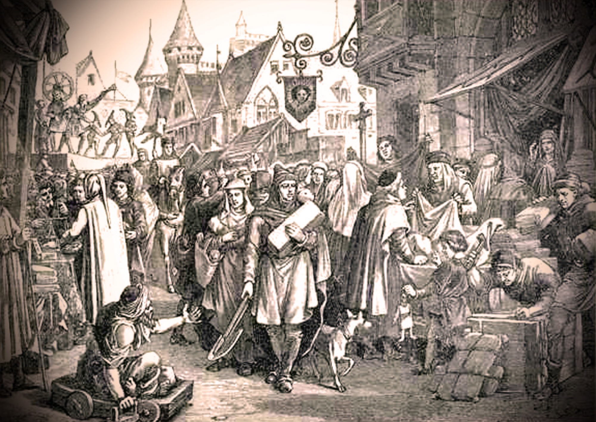
The material culture of the Champagne Fairs survives principally through architectural remains and numismatic evidence rather than fine art. At Provins — inscribed as a UNESCO World Heritage Site in 2001 — the thirteenth-century Grange aux Dimes (Tithe Barn) preserves cross-ribbed stone vaults and sculpted capitals that once sheltered a covered market during the fairs, as Jean Mesqui documented in his study Provins: La fortification d'une ville au Moyen Age (1979). The twelfth-century Tour Cesar, built under Henry the Liberal between 1152 and 1181, remains the most striking architectural artifact of comital authority. Underground, some 150 vaulted cellars carved from limestone — originally used for storing merchants' goods and for fulling cloth — constitute a remarkable archaeological ensemble. In Troyes, the dense fabric of timber-framed merchant houses, though largely rebuilt after the fire of 1524, preserves medieval cellar vaults on two levels that once served drapers and cloth merchants, as Elizabeth Chapin explored in Les villes de foires de Champagne (1937). The denier provinois, the coinage of the Counts of Champagne bearing a wool comb on its reverse, circulated so widely that it was copied by the Roman Senate mint as the denaro provisino by the mid-twelfth century. Sigillographic evidence from the comtal chancery, analyzed in studies such as "Emblematique et pouvoir en Champagne" on Academia.edu, shows the Counts still using non-heraldic equestrian seals into the 1180s. The best-known visual depiction of a Champagne fair is the nineteenth-century engraving "Une foire en Champagne au XIIIe siecle," published in Ernest Lavisse's Album historique (1898). Medieval manuscript illuminations of contemporary fairs — notably the miniature of merchants at the Lendit Fair near Saint-Denis in the Grandes Chroniques de France (BnF, c. 1375-1379) — provide analogous visual evidence for the commercial scenes that would have characterized the Champagne cycle.
The Champagne Fairs owed their preeminence to geography: the County of Champagne sat at the intersection of medieval Europe's principal north-south axis linking the cloth-producing cities of Flanders to the Italian mercantile republics, and the east-west corridor connecting the Rhineland to the Atlantic via the Paris basin. As R.D. Face demonstrated in "Techniques of Business in the Trade Between the Fairs of Champagne and the South of Europe" (Economic History Review, 1958), Italian merchants traversed the Alps via the Mont Cenis Pass to reach the fair towns, while Flemish traders followed the Scheldt valley south to link with the Seine river system. The four towns occupied complementary positions along the tributaries of the Seine: Troyes and Bar-sur-Aube on the Aube, Lagny-sur-Marne on the navigable Marne, and Provins on the Voulzie near the upper Seine. Heavy cargo — wine, grain, metals — moved by river, as Henri Laurent documented in La draperie des Pays-Bas en France et dans les pays mediterraneens (1935). The six-fair rotation calendar, analyzed by Felix Bourquelot in Etudes sur les foires de Champagne (1865), ensured nearly continuous commercial activity across the four towns. The Counts of Champagne secured this system through the conduit des foires — a formal safe-conduct guaranteeing merchant security even beyond county borders, extended by Philip Augustus to all royal territory in 1209. Fair guards (gardes des foires) policed transactions and enforced contracts, as Paul Huvelin examined in his Essai historique sur le droit des marches et des foires (1897). Within each town, dedicated quarters housed the fairs: at Provins the upper town (ville haute) contained the principal fair grounds, while merchant houses with vaulted cellars lined the streets below. Edwards and Ogilvie, in their reappraisal in Explorations in Economic History (2012), emphasized that this institutional infrastructure — security, property rights, regulated weights and measures — was provided by public authority rather than private merchant order.
Protected by the Counts of Champagne, the fairs drew merchants from across Europe. Flemish and northern French cloth was the primary commodity, traded alongside leather, furs, and spices from the East. Each fair followed a set structure: eight days for setup, followed by days allocated to cloth, leather, and spices by weight, concluding with a four-day financial settlement period. The fairs reached their zenith in the 13th century, becoming Europe’s principal clearinghouse for long-distance trade. Italian bankers — particularly from Genoa — conducted extensive financial operations, pioneering the use of bills of exchange and credit instruments. The troy weight system for precious metals takes its name from Troyes.
Decline set in after 1284–1285, when Champagne was absorbed into the French royal domain through the marriage of Joan I of Navarre to Philip IV. By around 1350, the fairs had dwindled to regional markets, superseded by permanent exchanges in cities like Bruges and Antwerp.
Images will be added as the project develops. Photographs by Larry Ng and from research sources.